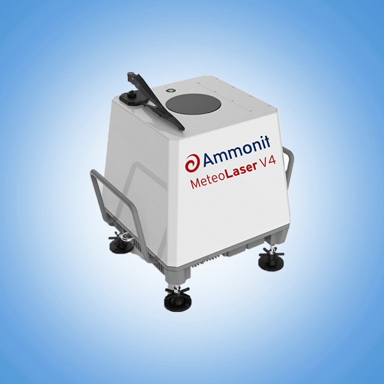
2024-04-15 22:26:19
MeteoLaser LiDAR | MeteoXperts Solutions
Menu Close

MeteoLaser LiDAR

Make: Ammonit                                      Model: S97210
✅ The MeteoLaser pulsed doppler LiDAR accurately measures horizontal and vertical wind speeds and directions up to 300 meters
✅ Measurand :  Barometric Pressure, Air Temperature and Relative Humidity
✅ Sensor Type : Pulsed Doppler LiDAR
✅ Signal Output : Emails, FTP and SCP, SFTP
✅ Supplied With : Factory report against golden LiDAR (not IEC conform)
Category:

MeteoLaser LiDAR: Mobile measurement for a wide range of applications :

MeteoLaser LiDAR, also known as a Light Detection and Ranging system, is a remote sensing technology that uses laser light to measure distances to a target. It is commonly used in meteorology to measure the wind profile in the atmosphere up to several kilometers in height.
The MeteoLaser LiDAR system emits a laser beam into the atmosphere and measures the time it takes for the light to travel to the target and back. By measuring the time delay and the wavelength of the laser light, the system can calculate the distance to the target. The system can also measure the wind velocity by analyzing the Doppler shift of the laser light reflected back from the target.
One of the advantages of MeteoLaser LiDAR is that it can measure the wind profile in the atmosphere with high vertical resolution and accuracy. It can also measure the wind in regions where traditional wind measurement techniques, such as cup anemometers, cannot reach, such as in the boundary layer or in the presence of obstacles.
MeteoLaser LiDAR systems can be classified into two types: pulsed and continuous wave. Pulsed systems emit short bursts of laser light, while continuous wave systems emit a continuous beam of laser light. Pulsed systems are typically used for wind profiling, while continuous wave systems are used for measuring aerosol properties and cloud height.
The MeteoLaser LiDAR system is used in a variety of applications, such as weather forecasting, air quality monitoring, and renewable energy assessments. In weather forecasting, it can be used to measure wind profile and temperature in the atmosphere to improve the accuracy of weather models. In air quality monitoring, it can be used to measure the concentration of particulate matter in the atmosphere. And in renewable energy assessments, it can be used to measure the wind profile at different heights to determine the potential for wind power generation.
Overall, MeteoLaser LiDAR is a powerful remote sensing technology that can provide valuable information about the wind profile in the atmosphere, which can be used for a wide range of applications. It offers a high level of accuracy, precision and vertical resolution, providing a unique tool for meteorology and atmospheric research.

The MeteoLaser pulsed doppler LiDAR accurately measures horizontal and vertical wind speeds and directions up to 300 meters. It measures pressure, temperature and humidity through the PTH sensor module.
The MeteoLaser LiDAR can be used
• in wind resource assessment,
• in micro-siting of wind farms,
• power performance of wind turbine,
• wind park monitoring,
• offshore wind measurement systems and other places where mobile wind measurements are required.

The Meteo Laser pulsed doppler LiDAR accurately measures horizontal and vertical wind speeds and directions up to 300 meters. It measures pressure, temperature, and humidity through the PTH sensor module.

Application and features of MeteoLaser LiDAR:

Application

Features

✅ In the evaluation of wind resources.
✅ The micro-siting of wind farms.
✅ The operation of wind turbines.
✅ The observation of wind parks.
✅ The Offshore wind measurement systems.
✅ Other situations where mobile wind measurements are necessary.
✅ AmmonitConnect remote access for configuration
✅ AmmonitOR Data Cloud for campaign monitoring
✅ Good results as expected from a pulsed LiDAR
✅ For wind resource assessment
✅ < 35 W without heating or cooling
Make

Apogee

Model

S97210

General Specification

:-

Type of LiDAR

Pulsed Doppler LiDAR

Number Of Laser Beams

4 laser beams (N, E, S, W)

Angle Of Laser Beam

28° to vertical

Measurement Range

40 to 300 m

Measurement Heights

12 heights

Measurement Cycle Duration

~0,8 s per beam,
~3,2 s for 4 beams

Accuracy Horizontal Wind Speed

0.1 m/s *

Wind Speed Range

0 to 80 m/s

Accuracy Wind Direction

1° *

Power Supply Requirements

18 to 32 V DC /
93 to 263 V AC (50-60 Hz)

Operating Condition

-40° C to 60° C

Humidity range

-0 % to 100 % RH
(non-sourced)

Protection Level

IP 67

Safety Standards

Class 1M IEC/EN 60825-1

Hardware Interface

4G-Router, Ethernet,
Laptop connection, USB for
GPS-tracking

Data Format

10 minutes files CSV files
1 second data CSV files

User Interface For Remote Access

Web application over AmmonitConnect (SSH reverse Tunnel)

Data Transfer Protocols

Emails, FTP and SCP, SFTP from AmmonitOR

Data Cloud

Ammonit OR Datacloud

Classification IEC 61400-12-1

Available for purchase

IEC Verification

Available on option

Factory Report Against Golden LiDAR

Included for free

Size

without packaging: 390 x 390 x 340 mm
with packaging: 600 x 600 x 600 mm

Weight

Without Packaging : 32 kg
with packaging : 60 kg